
Key findings
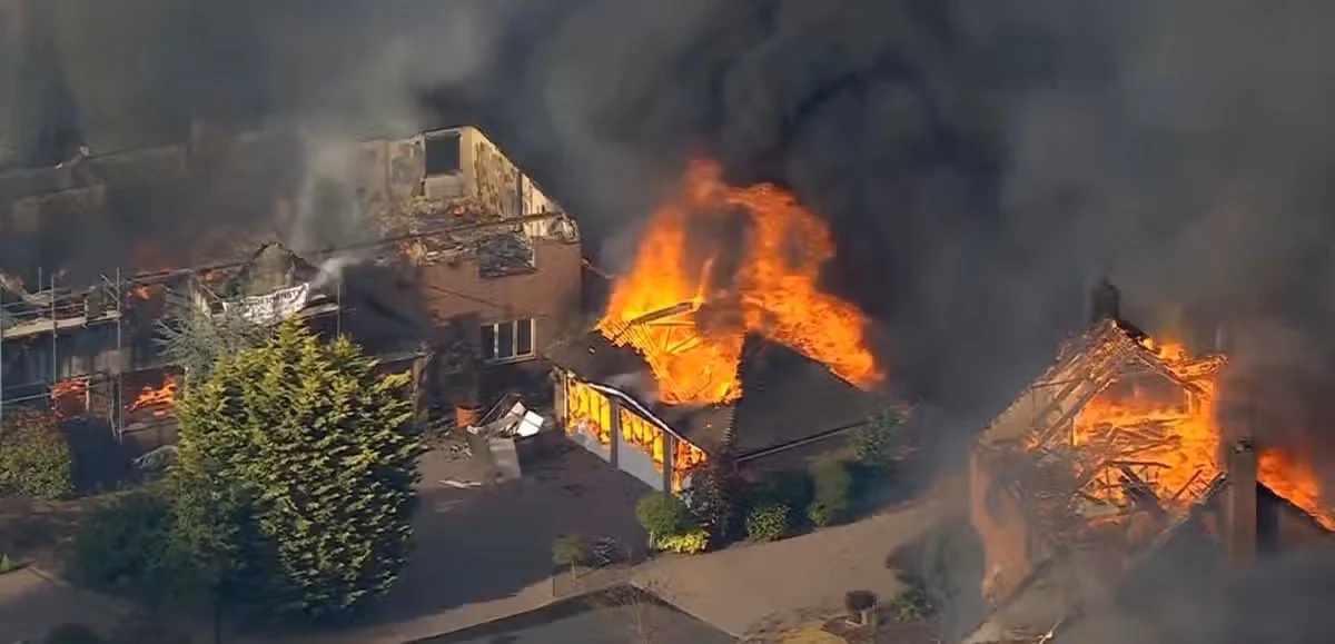
- The Stourbridge fire began on Thursday 13 August 2026 in grassland and spread into nearby homes. The cause remained under investigation as of 15 August; no conclusion about ignition should be drawn from dry conditions alone.
- The currently reported scale is substantial but still provisional: a local parliamentary source cited by Associated Press estimated that around 20 to 30 homes had been completely destroyed. A final incident assessment should come from West Midlands Fire Service and Dudley Council.
- Summer 2026 fires in France, Greece and elsewhere demonstrate that wildfire disruption reaches far beyond burnt land: it can close access routes, interrupt tourism and trade, threaten industrial premises, displace workers and overload local response capacity.
- For town centres, the decisive resilience question is not whether the retail core is surrounded by forest. It is whether its wider catchment has managed the interfaces between dry vegetation, homes, employment land, transport, utilities and public space.
- Sanctuary’s practical conclusion is that town-edge wildfire resilience should be built through maintained landscape design, shared operational protocols and SME continuity support—not treated as a one-off emergency-services issue.
The verified Stourbridge picture: serious, fast-moving and still subject to formal investigation
The Stourbridge wildfire began on Thursday 13 August 2026. West Midlands Fire Service’s chief fire officer told Associated Press that it was believed to have started in grassland before spreading to nearby homes, and that an investigation would be launched. This matters: prolonged heat and drought can create the conditions for rapid spread, but they do not establish an ignition cause. Any account that moves beyond the current investigation would be speculation (Associated Press, 2026). ↗
The best available public reporting as of Saturday 15 August puts the damage at an exceptional scale for an English town-edge fire. A Stourbridge representative cited by Associated Press estimated that approximately 20 to 30 homes had been completely destroyed. Reports also describe evacuations undertaken as fire direction became uncertain. Associated Press separately reported hospital treatment for people and firefighters in connection with multiple West Midlands fires; that regional figure should not be presented as a Stourbridge-only casualty count. The appropriate editorial position is therefore clear: the housing-loss estimate is a credible early range, but the definitive local damage, injury and response record remains to be published by the responsible authorities. ↗
This is not pedantry. In the first days after a major incident, numbers change while responders move from life safety to damage assessment. For local leaders, however, the operational fact is already plain: a fire that began in open vegetation crossed into the built environment quickly enough to turn landscape management, evacuation, housing security and recovery capacity into one connected challenge.
Why this is an urban-economy issue, not merely a countryside-fire story
Stourbridge should not be used to claim that every UK high street now faces the same direct wildfire exposure. It should be used to correct a narrower mistake: treating town centres as separate from the landscapes, neighbourhoods, access routes and utilities on which they depend. The relevant geography is the town and its catchment, not only the retail core.
Wildland–urban interface research defines the interface as the area where settlements meet or intermingle with flammable vegetation. A Europe-wide mapping study found that this interface covers around 7.4% of the continent, with substantial variation within countries and regions (Bar-Massada et al., 2023). ↗ The implication for UK places is not that Stourbridge should be treated as a Mediterranean settlement. It is that risk assessment should identify local interfaces at a sufficiently fine scale: parks beside housing, scrub near employment sites, dry verges beside evacuation corridors, unmanaged land behind retail parks, and wooded edges adjoining schools or care settings.
For businesses, the first losses may be indirect. Smoke can make premises difficult to use; a cordon can sever customer and staff access; staff may be evacuated or caring for displaced relatives; deliveries can fail; and a stretched fire-and-rescue service is simultaneously managing other incidents. The French fires of July 2026 made this interdependence visible: evacuations near Lège-Cap-Ferret affected homes, campsites and a major visitor economy at the height of the holiday season (Mahe, 2026). ↗
That is why resilience should not be reduced to installing a fire extinguisher in a shop unit. It concerns the ability of a local economy to continue serving residents, paying staff, communicating safely and reopening fairly when a disruption begins beyond the commercial centre. Sanctuary’s earlier analysis of heat risk makes the connected point that climate adaptation for high streets must include operational continuity as well as physical improvements: Heat is now a high-street risk: why UK town centres need climate-resilient retail strategies.
Europe’s 2026 fires reveal common disruption pathways—not a single transferable fire model
The summer’s European fires should not be treated as a league table of hectares burnt. Their practical relevance to UK towns is the repeated pattern by which a landscape fire becomes an economic and civic disruption.
In south-west France, the July fire near Lège-Cap-Ferret prompted evacuation of more than 10,000 people from homes and campsites during an initial phase, showing how tourism accommodation and local access can become emergency infrastructure almost immediately (Mahe, 2026). ↗ In northern Greece, more than 300 residents and visitors were evacuated by sea on 13 August after fire through pine forest threatened seaside homes. Earlier in July, a wildfire on the outskirts of Thessaloniki burned a factory and affected small businesses, illustrating how industrial edges can be exposed alongside residential areas (Associated Press, 2026; Reuters, 2026). ↗ ↗
The European Commission’s current approach is therefore more useful than a response-only lens. Its March 2026 framework puts prevention, preparedness, response and recovery in the same risk-management cycle, explicitly connecting wildfire resilience with infrastructure, cultural heritage, ecosystems and the economy (European Commission, 2026). ↗
There is an important caveat. The European Forest Fire Information System reported on 1 July that the 2026 season was then below 2025’s record level but above the 2006–2025 average for the same point in the year. That is an early-season benchmark, not a final assessment of the 2026 season and should not be used to minimise later events. ↗ The analytical lesson is not that Stourbridge is identical to Crete or Gironde; it is that different places can share the same vulnerability chain: severe fire weather, an ignition, continuous dry fuel, exposed assets, constrained movement and uneven recovery capacity.
Green infrastructure is not automatically fire-resilient infrastructure
A tempting response is simply to call for more greenery. The evidence supports a more demanding position: green infrastructure must be designed, maintained and governed for the risks it may face. Fire behaviour depends on the interaction of ignition, fuel and weather. In UK conditions, grassland, heathland and woodland edges can become high-risk where vegetation is dry, fuel is continuous, access is poor or water supply is constrained (Forest Research, 2026). ↗
This does not make trees, parks or nature-based projects a problem. It means that resilience cannot be bought through planting alone. A systematic review of wildland–urban-interface measures identifies five intervention families: clearance distances, landscaping, wildland fuel management, land planning, and building design and materials. It also finds that maintenance is central to preparedness and that the evidence base still has too few robust quantitative comparisons to justify a single universal prescription (Taccaliti et al., 2023). ↗
UK policy evidence similarly warns against simplistic choices. Parliament’s POSTnote records broad agreement that wildfire risk should be incorporated into land management, while noting credible disagreement over the effects of interventions such as rotational burning, tree planting, rewilding and peatland rewetting in particular settings (Wentworth and Tasker, 2024). ↗ The practical conclusion is place-specific planning: identify the fuel, the likely fire path, the assets at risk and the maintenance capability before deciding what a resilient landscape should look like.
Stourbridge also exposes a second constraint that plans often overlook: water. Government drought guidance states that firefighting water access is essential during dry periods and calls for water undertakers to plan with fire and rescue services for drought conditions (Environment Agency, 2026). ↗ A town-edge resilience plan that maps vegetation but not hydrants, water availability, appliance access and key road pinch points is incomplete.
A Sanctuary framework: from fire incident to town-edge resilience capability
Sanctuary’s interpretation is that towns need a practical capability model rather than a stand-alone wildfire strategy document. The aim is not to predict every ignition. It is to reduce avoidable exposure, enable faster and safer decisions, and protect local economic life while statutory responders deal with the emergency.
**1. Map the town-edge exposure system.** Within 90 days, convene the local authority, fire and rescue service, water company, landowners, housing providers, business representative bodies and community organisations. Map dry-fuel areas, known access constraints, schools and care settings, business clusters, evacuation and delivery routes, water points, and places likely to become rest centres. This should be an operational map, updated before each high-risk season—not a decorative green-infrastructure plan.
**2. Move from landscaping projects to maintained fuel-and-access management.** Commission risk-based maintenance plans for parks, verges, rights of way, development edges and vacant land. Plans should specify ownership, inspection frequency, access clearance, vegetation treatment, ecological safeguards and who pays for continuing maintenance. The central test is whether the intervention creates a safer, more discontinuous landscape without shifting risk onto neighbouring communities.
**3. Give SMEs a simple continuity protocol.** Business support should provide a short, usable template covering staff contact, air-quality and closure decisions, stock and data protection, remote trading, supplier alternatives, insurance records, and communication with customers. Trigger points should be linked to official alerts and local responder advice, not to informal social-media reports. This is a strong fit for SME Growth & High Street Regeneration, where place renewal is treated as the capacity of a local economy to operate through disruption as well as attract footfall in normal conditions.
**4. Make recovery locally accountable.** Recovery should begin with household safety, access, temporary accommodation, livelihoods and small-business cashflow—not with a preselected redevelopment narrative. The emergency can expose longstanding weaknesses in insurance access, temporary workspace, transport and public-space maintenance. Those problems require transparent local evidence and resident participation before capital schemes are designed.
**5. Run a seasonal exercise, not just a communications campaign.** England is increasing national wildfire capability through specialist teams and equipment, but local preparedness still depends on place-based coordination (MHCLG, 2026). ↗ A tabletop exercise should test a realistic scenario: a grassland fire closes an access route, smoke affects a school and retail area, staff cannot travel, and water demand is high. The value lies in finding hand-off failures before an incident does.
The wider point is deliberately challenging: town-centre resilience is not secured solely by improving the centre. It is secured by managing the physical and organisational edges on which the centre relies. Stourbridge makes that dependency visible.
What should happen next in the West Midlands
The immediate priority remains support for displaced residents and the safe completion of the emergency response. Once the formal incident record is available, the West Midlands should commission an independent learning review with a narrow practical remit: how did the fire move from grassland to homes; what constrained access, water or communications; how were evacuations managed; which organisations absorbed the economic disruption; and what maintenance, planning or continuity changes are justified by the evidence?
That review should avoid two errors. The first is treating the event as a freak occurrence that requires no durable change. The second is assuming a single dramatic intervention will solve a multi-factor problem. The evidence instead supports an integrated, maintained and locally governed approach across prevention, preparedness, response and recovery (European Commission, 2026; Salpina et al., 2026). ↗ ↗
For Sanctuary, the editorial position for review is that wildfire now belongs in the same local economic resilience conversation as heat, drought, flooding, infrastructure failure and business continuity. It should be assessed on evidence, embedded in town-edge operations, and funded as a continuing capability rather than a short-lived reaction to a shocking event.
Research foundation
References
- Associated Press (2026). European countries battle multiple wildfires as record heat grips the continent. Associated Press.Source ↗
- Stephane Mahe (2026). France wildfire forces thousands to flee as tinder box conditions persist in warming Europe. Reuters.Source ↗
- Alexandros Avramidis (2026). Wildfire burns factory and threatens houses in Oreakastro, north of Thassaloniki, Greece. Reuters Connect.Source ↗
- European Commission Joint Research Centre (2026). Current wildfire situation in Europe. European Commission.Source ↗
- Directorate-General for European Civil Protection and Humanitarian Aid Operations (2026). Commission launches new strategy to tackle rising wildfire threat. European Commission.Source ↗
- Ministry of Housing, Communities and Local Government (2026). Government strengthens wildfire resilience heading into summer. GOV.UK.Source ↗
- Environment Agency (2026). Drought: how it is managed in England. GOV.UK.Source ↗
- Forest Research (2026). Wildfire. Forest Research.Source ↗
- Jonathan Wentworth and Sam Tasker (2024). Wildfire risks to UK landscapes. UK Parliament POSTnote.Source ↗DOI: 10.58248/PN717
- Avi Bar-Massada, Fermín Alcasena, Franz Schug and Volker C. Radeloff (2023). The wildland–urban interface in Europe: Spatial patterns and associations with socioeconomic and demographic variables. Landscape and Urban Planning, 235, 104759.Source ↗DOI: 10.1016/j.landurbplan.2023.104759
- Flavio Taccaliti, Raffaella Marzano, Tina L. Bell and Emanuele Lingua (2023). Wildland–Urban Interface: Definition and Physical Fire Risk Mitigation Measures, a Systematic Review. Fire, 6(9), 343.Source ↗DOI: 10.3390/fire6090343
- Dana Salpina, Veronica Casartelli, Angelica Marengo and Jaroslav Mysiak (2026). Understanding cross-sectoral wildfire risk governance: Lessons from mix-method analysis of the wildfire risk governance in Italy, Greece, and Land Brandenburg. International Journal of Disaster Risk Reduction, 142, 106201.Source ↗DOI: 10.1016/j.ijdrr.2026.106201
- Sanctuary Consulting & Development Group. Hero image: administrator-supplied photograph. Owner supplied / permission confirmed.Image source ↗
Related Sanctuary capabilities
From analysis to implementation.
Discussion
No approved comments yet.